
ENviSION-EO
Background

Today, particularly so in the face of climate change and the need to meet global food and water security requirements, there is an urgent need for a better understanding of natural processes in the Earth System and of land surface interactions (LSIs). This is now widely recognised by the global scientific community as a matter requiring urgent attention for further investigation. In purview of the above, being able to accurately estimate parameters such as latent (LE – so called evapotranspiration) and sensible (H) heat fluxes as well as surface soil moisture (SSM) is of paramount importance, given their linkage to many physical processes of the Earth system. Furthermore, water plays a central role in the spatiotemporal variations of carbon dioxide (CO2), water and energy flux dynamics (LE and H fluxes), and is a major driver of key biosphere variables such as Gross Primary Productivity (GPP), Carbon assimilation rates (CO2 flux), Ozone (O3) flux, Net Ecosystem Exchange (NEE) and Water Use Efficiency (WUE) . Thus, justifiably, developing methodologies to understand LSIs at different spatial scales and their response to climate change is essential to assessing the dynamics and distribution of key biophysical parameters and to ensure long term security of the Earth's terrestrial ecosystems.
Earth Observation (EO) has undoubtedly played a key role in this direction, particularly as regards the retrievals of LE & H fluxes and SSM, providing products that satisfy many practical applications and research requirements. Yet, at present EO-based prediction of such parameters is done in quite diverse, unconnected ways. Additionally, the vast majority of the techniques have been explored using primarily, if not solely, EO data from spaceborne sensors. The use (or possible integration) of airborne EO data such as those from unmanned aerial vehicles (UAVs) has so far been poorly explored. This despite the advantages (e.g. on demand acquisition, high spatial resolution) and their potential for integration in so-called "smart applications" suitable for mobile devices (smart phones). Advances in UAV technology --both hardware and software-- over the last 5 years or so have revolutionised the way EO data can be integrated in science and practical applications. Furthermore, global EO-based operational mapping of LE/H fluxes and/or SSM, particularly at high spatio-temporal resolution, is lacking or is underdeveloped.
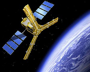
The key limitations of existing relevant operational products seem to include the coarse spatial and temporal resolution, limited geographical coverage and various soources of uncertainty in algorithm formalisms . The recent launch of new satellites (e.g. ESA’s SMOS & Sentinels, NASA’s SMAP and Landsat 8), demonstrates the real need and the true potential of spaceborne sensors to provide spatially and temporally consistent and reliable information at previously unattained spatio-temporal resolutions. In this context, particularly the synergy of EO with land biosphere models (LBMs), specifically Soil Vegetation Atmosphere Transfer (SVAT) models, has been identified as a promising avenue towards addressing this challenge.
ENviSION-EO Objectives

ENviSION-EO’s overall aim is to explore both the SimSphere's and "triangle's" ability to pioneer the development of robust, state of the art, viable methodologies to observe, over range of scales, a multitude of LSIs globally exploiting contemporary EO data. As such, the proposed research aims to address the following 4 objectives:
Objective 1:
| Facilitate the implementation of cutting-edge modelling interventions to the SimSphere LSM in a multifaceted way towards developing a land surface modelling tool for advancing our understanding and modelling of LSIs; |
Objective 2: | Appraise the “triangle's” potential for providing estimates of key parameters characterising LSIs using Sentinels-3 and UAV data respectively; |
Objective 3:
| Extend the “triangle” allowing the retrieval of new, previously unexplored biophysical parameters characterising LSIs and investigate the presence of new physical properties encapsulated in the satellite-derived Ts/VI feature space; |
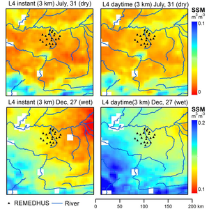
Objective 4: | Investigate the spatio-temporal downscaling of the SSM SMOS operational product at resolutions suitable for watershed to regional studies via the synergies with Sentinel-3 unfolding the ‘triangle’ potential for this purpose |
The project duration is 4 years, ending in September 2019.
Innovation & Impact

A first novel aspect of ENviSION-EO lies in the series of further developments to SimSphere LBM (Obj. 1). These will revolutionise the model by making it more applicable and well-rounded, opening up a whole new world of users on a global scale, and thus putting it in the forefront of LSI-related research & applications.
Innovative and contemporary techniques that will be developed during Obj. 2 will allow developing for the first time a variant of the "triangle" usable with Sentinel-3 (ESA's most recent satellite) and UAV data. This will allow provision of spatio-temporal estimates of key parameters characterising LSIs at previously unattained scales, which is extremely valuable in practical applications and research alike. The action also aims to elucidate, for the first time as well, the potential of extending the “triangle" to obtain new biophysical parameters and to identify the existence of new relationships in the physical properties encapsulated in the Ts/VI domain (Obj. 3). Findings of this work will provide a major breakthrough towards advancing our ability to estimate CO2 & O3 fluxes, GPP and WUE from space, expanding the “triangle’s” use worldwide and revealing a whole new range of biophysical properties potentially encapsulated in the Ts/VI feature space.
The unique contribution of ENviSION-EO on offering a scheme to spatio-temporal downscaling of the SSM SMOS global operational product (Ob. 4) derived from ENviSION-EO will allow for the first time monitoring of the Earth's SSM at previously unattained resolutions, transforming how we utilize EO data to obtain this parameter from space. In overall, results are also expected to have direct impact on a number of activities by both governmental and commercial bodies (e.g. EU's Copernicus Services). Apart from policy makers and researchers, the public will also have access to ENviSION-EO products and software tools for use in further research or applications. The latter can greatly increase the societal return of the economic investment in the project.
Contacts
Any further information required or questions related to TRANSFORM-EO research can be addressed either to the Marie Curie fellow (Dr George P. Petropoulos, email: petropoulos.george<at>gmail.com) or the Supervisor (Professor Dionisios Hristopoulos, email: dionisi<at>mred.tuc.gr)